Posts

George Edward

Image
  George Edward was born on 25th August 1865 at 246 Bath Street, Glasgow: This is still standing 159 years later: It is the door with the bins on either side (and presumably the upper floors) and may have looked grander at the time! George was born partially deaf. George's father, David,  and described his occupation as Master Watchmaker, but I suspect this covered more general work in jewellery, silverware etc.  He had married Mary Anne Nisbet on 14th September 1864 so George was their first born. George's siblings were Margaret (born 1868), Mary (1871), Edith (1872), Winifred (1875), David (1880) and Catherine (1887, 22 years after George). The Edward family are missing from the 1871 Census (possibly travelling overseas?),  Around this time, George was beginning his education at "The Glasgow Institution", which I take to be the Glasgow Deaf and Dumb Institution, recently moved to a new building at Prospecthill Road, Langside (see this link for more): Rather alarmi...

Mosshead, Gartconnell, North and South Baljaffray: four lost farms north of Bearsden

Image
  I found this fascinating map on the Scotland's People website.  It is dated 1945 and was part of a series covering farmland in Scotland.  In the area I have selected above you can see Schaw House bottom right, Edgehill Road immediately to the right of that and parallel to the right of that, Gartconnell Road.  The black buildings marked on the extreme right, just above the marking "30" on the vertical side of the map, is Gartconnell Farm.  Heading north (and just below the letter C in KILPATRICK is Mosshead Farm.  Going north again to the top of the photo is South Mains Farm (still a working farm in 2024) on Craighdu Road.  Following this road left to the then crossroads (now a busy roundabout) and going straight across into what we now call Baljaffray Road you can see another two farms, North Baljaffray and South Baljaffray. All the photos are taken from air the Britain from Above website GARTCONNELL The first photo of Gartconnell is from 1928: We a...

Roman Road North Side

Image
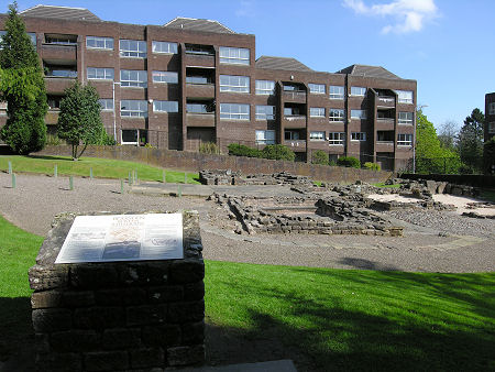
The contrast between the remains of a Roman bath house and the 1970s flats at Roman Court on Roman Road in Bearsden make an interesting contrast.  But what was there before the flats? Having searched high and low on the internet over several years I could not find anything.  Fortunately, the Britain from Above website includes several aerial photos that give a general idea.  I've presented them in the date order in which they were taken. This is a 1928 view from roughly above Asda on Milngavie Road looking back towards Bearsden Cross.  Roman Road runs across the bottom left corner and a car is approaching the corner of Grange Road.  To the right of the road as we look, the north side, are the villas replaced by Roman Court.  I believe Manse Burn is just visible through the trees at the rear of the villas. If you are a little disorientated, this is the same view but with a little less magnification and a wider context: In the top left corner you can see the ...